News
19.01 2026
Cadastral Registration: The Application of Artificial Intelligence (AI) by Farmers and Agricultural Enterprises

The success of modern agricultural businesses depends largely on effective land management, which requires not only accuracy but also the speed of processing colossal volumes of data. The Soft.Farm team decided to take an innovative approach and, through the use of artificial intelligence (AI), radically transform and simplify this routine work for farmers, analysts, and land managers. Cadastral registration is a main component of agricultural software.
16.10 2025
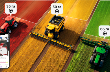
GPS Monitoring of Agricultural Machinery and Calculation of Completed Hectares

Modern agriculture demands precision and transparency at all stages of production. In the era of digital transformation, the success of an agricultural enterprise directly depends on its ability to effectively manage resources, minimize losses, and optimize every process. One of the tools for achieving these goals is the innovative "Technique Tracks" module within the agricultural machinery monitoring system, developed by the Soft.
01.09 2025
Soft.Farm: digital transformation of Ukrainian agribusiness

In the conditions of the modern agricultural market, the success of a farm is determined not only by the quality of the land or crop yield, but also by the company efficiency to manage information. Data is becoming a new “fuel” for development, and it is they who help farmers make the right decisions. Soft.Farm is a Ukrainian online platform that has been helping agricultural producers digitize business processes and control all stages of production for over 10 years.
18.06 2025
Lease Agreement Management: A New Level of Land Plot Visualization

During document management related to the land bank, difficulties often arise due to the complexity of data filtering, inappropriate visualization of plots, partial processing of information, etc. In this regard, there is a need to form lists of cadastral plots by individual characteristics. To solve these problems and expand the functionality of the Soft.Farm web service, our team has developed a new module "Lists".
07.04 2025
CRM for an agricultural land manager or How to organize the accounting of land lease agreements in modern conditions

Land lease is a contract-based fixed-term paid ownership and use of a land plot necessary for the tenant to conduct entrepreneurial and other activities. The objects of lease are land plots owned by citizens, legal entities, municipal or state property. The lessor is obliged to transfer the land plot to the tenant for a fee for possession and use for a certain period, and the tenant is obliged to use the land plot in accordance with the terms of the contract and the requirements of land legislation, in accordance with the land lease agreement.