Land Bank Report
22.01 2020
Soft.Farm takes into account the peculiarities of cadastral registration, so the digitalization of data on your fields every day becomes easier. Due to the capabilities of the report generation function for land plots, it is not necessary to view a lot of paper documentation in order to collect information together. All necessary information is generated in an electronic document. A convenient visualization format combines cadastral data for each specific field in the form of a report.

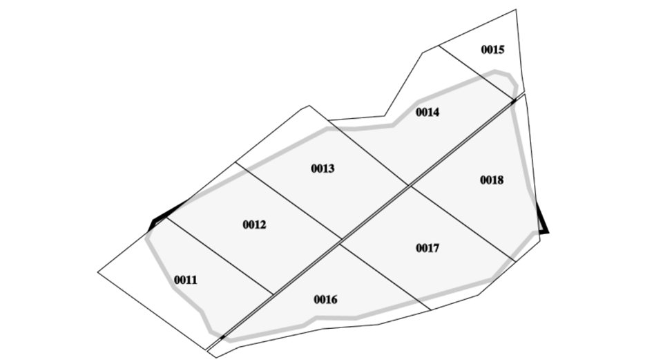
To conduct a quality audit of a land bank, it is enough to take three simple steps. The first step is to enter the field outlines. They can be downloaded as KML files or manually circled. The location of the fields will be instantly displayed on the map, and if you turn on the cadastral plots layer, you will immediately see the “chessboard” of land plots within each field. The second step is to enter cadastral numbers. You can load in the program ready-made excel files with cadastral numbers that the company has or order automatic loading of plots within your fields using the “Cadastral Number” function. The third step is to fill out documentary information on shares and vectorize the contours. This can also be done on your own or you can use the functions “Register of rights” and “Share's contours” to automatically download data. All cadastral information has been entered, which means that you can generate a high-quality report.

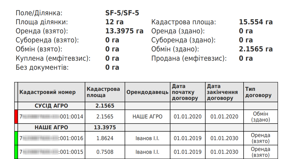
The first sheet of the report reflects all the information about the field, namely: its map with information about the area, data on crops with the dates of sowing and harvesting, as well as crop products, planned yield and gross harvest. On the second sheet, a report on the location of the cadastral plots is visible. It is important that the units are tied to the field. In this case, the “chessboard” of their placement will be reflected on the map and it will be easy to analyze the coincidence of the boundaries of the plots with the electronic maps of the fields of your agricultural enterprise. Next, summary cadastral data for the field and information in the form of a table in which the cadastral numbers of the plots, their area, tenant and lessor, the start and end dates of the lease agreement and its type are displayed. Next to the cadastral numbers is a color identification of the term of the lease, which helps to quickly determine the areas for which you need to renew or reissue documents. The information in the table is divided by tenants, so it is easy to identify shares of competitors for planning and implementing the exchange. Plots for which you need to double-check the agreement will be visible, namely whether everything is in order with the documents, whether neighbors will apply for your land, whether the agreement is on lease or has already been exchanged.
Prompt receipt of a cadastral report allows you to identify problem areas and respond in time to the expiration of lease agreements, as well as not to lose the most important information on the field and use the potential of each site to 100%.
Back to news list