Mobile application for working with PCMU, SRRR and layers of the cadastral map of Ukraine
07.09 2021
The digitalization of the land bank is an integral part of the inventory of the land of an agricultural enterprise. It helps to make the maintenance of cadastral records easier and more convenient. Land portals, web services, official electronic sources of cadastral data are used not only by agricultural firms and land surveyors, but also by individuals, lawyers, notaries, banks, real estate agencies, for which it is important to receive up-to-date information to ensure its reliability.
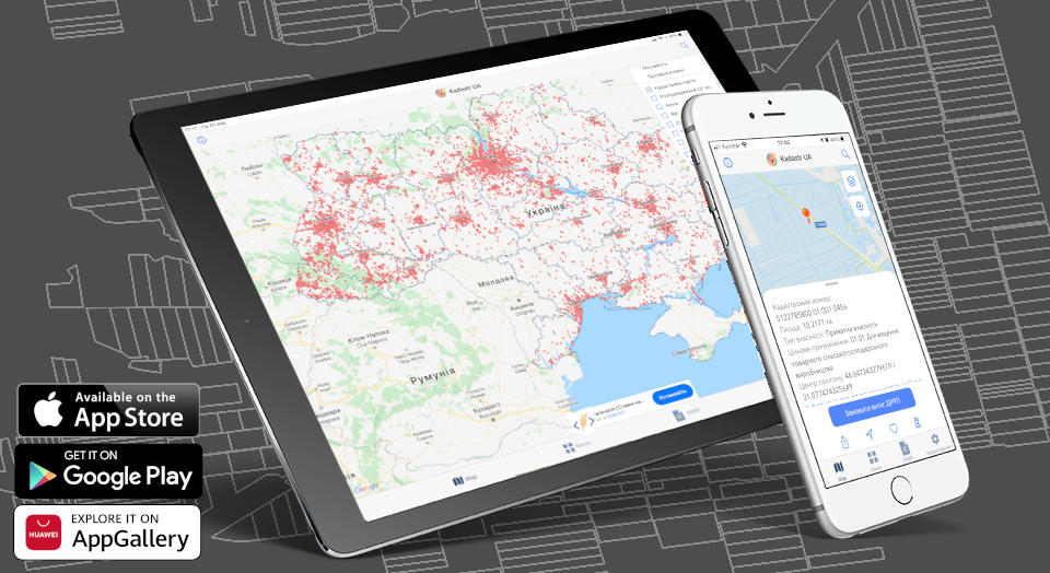
Often the necessary information is located in different programs, which is not always convenient for users. And if you don't have a computer at hand, then quick access to data becomes even more difficult. To solve this problem, you can use the mobile application «Cadastre UA», which works on devices with Android and iOS platforms!
«Cadastre UA» has an intuitive interface, so no implementation costs are required. The functionality of the application is constantly expanding and supplemented, which makes it possible to use it in daily work. Our team has expanded the capabilities of «Cadastre UA» on iOS and now it is possible to receive up-to-date information from the State Register of Real Rights to Real Estate (SRRR), which contains registration information not only about the land plot, its owners and tenants, but also about the expiration dates of the concluded lease agreements as well as their types. The extract from the Register can be viewed on the screen or downloaded to a mobile device in PDF format, where it will be available at any time.

With the opening of the land market, we have expanded the capabilities of the «Land sale» layer. Now it allows market participants 24/7 to find and receive complete information about the plots for sale using resources such as Brok.land, dom.ria.com and olx.ua. Indicating the cadastral number gives its exact localization, and clicking on the link opens ads, photos and contacts of the seller. Thanks to this layer, which has synchronized all relevant data on auctions, the land market of Ukraine is on one map. You can see the area and configuration of the plot, its intended purpose, form of ownership, the presence of disputed territories, cadastre errors identified by the owners, the price of the object being sold, etc.
For the convenience of users, the number of map layers available for display is constantly increasing. In addition to the ability to select the type of map, you can display the PCMU layer, the management of agricultural land, the layers of crops, the lands of the nature reserve fund and the «Emerald Network», as well as the innovative layer «Popularity of lands», which opens up new analytical opportunities.
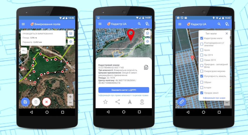
The mobile application saves the browsing history, and for a quick search, you can add the desired land plots to the list of «favorites», where they will be available even offline. The function of sending cadastral numbers and information about them using messengers allows you to exchange information, and the ability to read the news of the State Geocadastre directly from the mobile application helps to keep abreast of the latest changes that relate to the activities of the cadastral service.
«Cadastre UA» is a fast, modern, affordable and safe tool for working with a land bank. Data from the mobile application can be synchronized with the web version of Soft.Farm at any time and used in further work.
Back to news list