News
05.05 2021
Security of the land bank of an agricultural enterprise and control of changes in land lease agreements

According to the Land Code of Ukraine, land monitoring is a system for monitoring the state of land in order to timely identify changes, assess them, prevent and eliminate the consequences of negative processes. It is an important management function in the use and protection of land, regardless of the form of its ownership, purpose and nature of use. With the development and growth of the land market, it became necessary to track the dynamics of changes in the factors influencing it.
26.04 2021
Attention!
Dear users, we are working on improving the Soft.Farm web service and maintaining the stability of its functioning. We inform you that on April 28, 2021, from 06:00 to 14:00, scheduled maintenance work will be carried out, so the system will be unavailable at the specified time. We apologize for any inconvenience this may cause and thank you for your understanding!
14.04 2021
Field eData portal, visualization Precision Planting .2020, shape
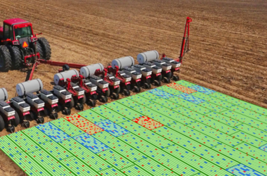
The concept of precision farming is based on the idea of the existence of heterogeneities within the same field, which are identified and evaluated using the latest technologies, such as global positioning systems, special sensors, aerial and satellite imagery, as well as specialized programs for farm management based on geographic information systems. The collected data is used to assess the optimum seeding density, calculate the application rates of fertilizers and plant protection products, more accurately forecast yield and financial planning.
07.04 2021
Land audit as part of a comprehensive territorial development plan
The main goal of the decentralization reform is to transfer a significant part of powers, resources and responsibility from the executive authorities to local self-government bodies. The concept is to unite villages into large communities in order to transfer broad financial and managerial autonomy to such entities. On June 12, 2020, the Cabinet of Ministers of Ukraine adopted a decree on the definition of administrative centers and the approval of the territories of the communities of the regions.
03.03 2021
Stop land raiding: how to put cadastral accounting in order using the Soft.Farm system
Lease of land is a term-based paid ownership and use of a land plot based on a contract, which is necessary for a lessee to carry out entrepreneurial and other types of activities. According to the lease agreement, the lessor is obliged to transfer the land plot to the lessee for possession and use for a certain period of time, and the lessee is obliged to use the land plot in accordance with the terms of the agreement and the requirements of land legislation.