New generation cadastral registration: why a map is no longer enough for effective land bank management
26.08 2026
In many agricultural enterprises, land bank management is still limited to reviewing a map with land plots. However, a modern land bank is much more than a set of contours of cadastral plots on a map. These are hundreds or even thousands of lease agreements, information about share owners, a list of cadastral numbers, registration data and a history of changes for each plot. This entire data set must be constantly monitored.
That is why professional cadastral accounting from Soft.Farm today is not just a tool for displaying land plots, but a comprehensive digital land bank management system.
Why it is important to start digitization today
The risks become greater if the land bank is maintained in Excel spreadsheets, paper archives or various separate programs.
It can be:
– missing the expiration dates of lease agreements;
– loss of documents;
– errors in land accounting;
– duplication of information;
– difficulty in finding the necessary documents;
– risk of losing land due to untimely response;
– lack of relevant information for management.
Digitizing the land bank in the Soft.Farm system makes it possible to combine all information in a single environment and significantly reduce the impact of the human factor.
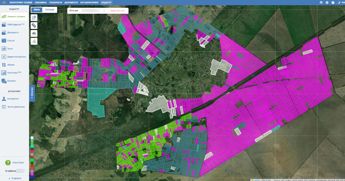
Professional cadastral accounting is an entire ecosystem
A modern land bank management system is a complex of interconnected tools that automate all processes of working with land.
1. Cadastral accounting of the land bank
The system forms a complete database of land plots with the ability to:
– registration cadastral numbers;
– display plots on the map;
– control geofence areas;
– view overlays;
– analyze the structure of the land bank;
– group land by various parameters.
Each land plot has a full digital card with a full history.
2. Maintaining lease agreements
The formation of a land bank is based mainly on lease agreements. In the system, you can:
– maintain your own complete register of agreements and control their validity periods;
– store all additional agreements;
– print agreements and accompanying documents;
– mass upload the necessary documents using templates;
– perform operations with exchange files (import, export).
3. The “Security” function for tracking changes by the enterprise’s USREOU code
Land bank management requires constant monitoring of changes that may affect the rights to use land plots. The system allows you to track changes by the enterprise’s USREOU code and promptly receive information about registration actions related to the tenant. This provides an opportunity to respond in a timely manner to data updates, control the legal status of counterparties, avoid risks when reissuing contracts and maintain the relevance of information in the land bank. Automatic monitoring significantly reduces the need for manual checks and helps not to miss important changes that may affect the enterprise’s economic activities.
Downloading and updating information from state registers allows you to quickly check current information about land plots. This helps to quickly detect changes and keep information up to date.
4. Artificial intelligence search and analytical reports
Thanks to modern search tools, you can quickly find the necessary information even in large data sets. The built-in artificial intelligence in the "Additional filters" section helps to find the necessary land plots for any non-standard query, analyze information and form the necessary samples.
The system also contains a wide range of reports for managers, land managers, lawyers and accounting.
5. Land exchange
Consolidation of the land bank is one of the key elements of effective agribusiness. Soft.Farm allows you to keep full records of land exchanges, record all agreements between the parties, control the history of changes and store the necessary documentation in a single database. Thanks to this, the company can analyze the effectiveness of the exchanges, optimize the location of land plots, reduce costs for logistics and field cultivation, and avoid confusion when processing documents. All information about exchanges is integrated with cadastral records, lease agreements and cartographic data, which provides full control over the structure of the land bank and simplifies its management.
6. CRM for working with shareholders
Working with land owners is not limited with the signing of the contract. The CRM module allows you to keep a complete history of interaction with each shareholder and helps to monitor the implementation of agreements. It contains:
– contact details;
– documents and information about leased plots;
– date and time of each request;
– data on the communication carried out;
– reminders.
All information is in one place and is available to responsible employees. The system also automates financial accounting of mutual settlements with land share owners. The capabilities include accounting for accruals and calculation of rent. This significantly reduces accounting time and minimizes the number of errors.
7. Filter system and convenient lists
Thanks to the extensive filter system, any information can be quickly found among owners, tenants, types of contracts, plots without contracts and contracts that are expiring. You can get your own lists of cadastral numbers and other specialized selections thanks to the "Lists" section.
Mobile apps for field work
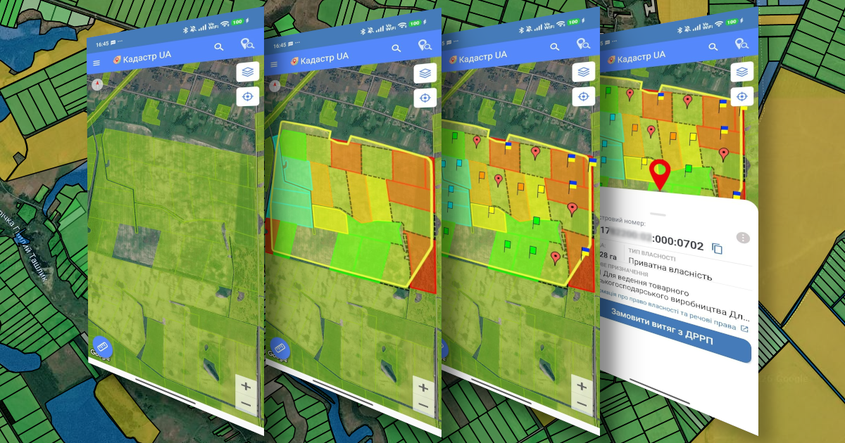
Measuring fields no longer requires paper maps. A modern land surveyor can work directly in the field, having all the necessary information about land plots at hand. That is why the software ecosystem includes the mobile application "Cadastre UA" (iOS / Android), which synchronizes with the web version and provides the ability to perform basic operations directly from a smartphone or tablet, as well as the mobile application "Fields Areas Measure" (iOS / Android).
With the help of these two tools, you can:
– measure the area of land plots using GPS;
– determine the actual boundaries of fields directly on the ground;
– compare actual contours with cadastral data;
– quickly find the desired land plot on the map;
– view information about the plot, lease agreement and owner;
– record changes in the boundaries or condition of the land plot;
– transfer measurement results to the web version without re-entering data.
For enterprises that require maximum measurement accuracy, integration with GNSS antennas from our partners is available. This solution provides significantly higher accuracy of coordinate determination and is an indispensable tool for land surveyors, cadastral specialists when clarifying land boundaries, conducting inventories, preparing documentation and resolving disputes.
As a result, employees receive a modern field tool that allows them to quickly conduct measurements, check actual land use and synchronize all results with the land bank management system. This reduces field work time, minimizes errors and ensures high data reliability.
Cadastre UA
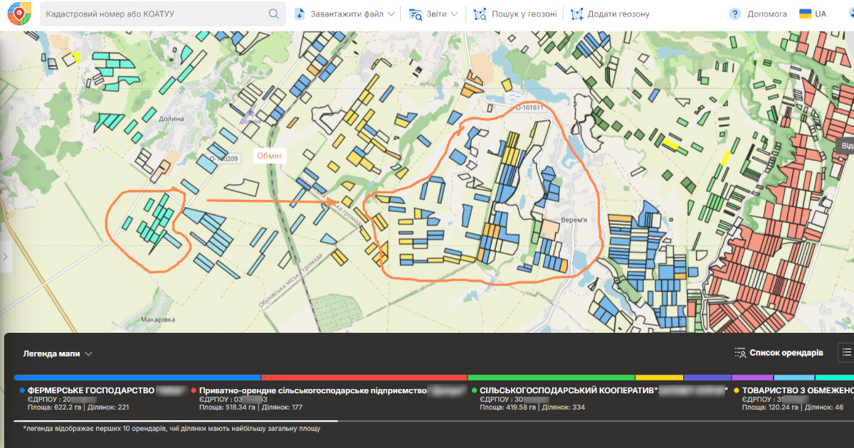
A separate component of the land bank management ecosystem is the web service "Cadastre UA". It allows you to find new land plots and analyze the land fund within village, town and city councils; monitor changes in your land bank and track the situation with lease agreements with neighbors.
With "Cadastre UA", you can analyze the competitive environment, and also, thanks to the functionality for searching for land auctions, find promising areas for expanding the land bank. In this way, the company receives not only information about its own lands, but also a powerful analytical tool for strategic growth.
So, professional cadastral accounting is not just a color map. The sooner the company begins digitalizing the land bank, the easier it will be to control each land plot, minimize the risks of losing leased land, optimize the work of employees and make informed management decisions.
Investments in a professional cadastral accounting system are investments in the safety, efficiency and stable development of the agricultural business.
Back to news list